> Development > Disaster Management


The catastrophic floods paralyzing Assam are driven by a violent mix of severe monsoon anomalies and deep environmental breakdown. Assam State Disaster Management Authority (ASDMA) data shows that over 650,000 residents have been displaced or affected by rising waters. Record-breaking rainfall shocks have struck upstream catchments, with specific districts recording a staggering 400% excess in precipitation within narrow 72-hour windows.
As a former Senior Professional Engineer for the St. Johns River Water Management District—one of five premier hydrologically bound water management entities in Florida, USA—I see striking technical similarities between modern flood challenges and the structural fixes required to save the Brahmaputra and Barak basins.
The core of the issue is not just the rain; it is how the landscape responds to it. Unscientific open-cast coal mining, illegal stone quarrying, and extensive vegetation removal in the hills of Assam, Nagaland, and Arunachal Pradesh have stripped away the natural forest buffers that hold topsoil together.
When heavy monsoons hit these bare hills, billions of tons of sand, gravel, and silt wash directly downstream into the river networks. This massive sedimentation fills river channels, making them shallow and drastically lowering their water-carrying capacity. As a result, even standard seasonal downpours cause local rivers to spill instantly over their banks and submerge nearby plains.
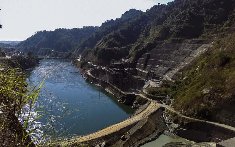
Photo credit: NEZINE
This crisis is further worsened by the operations of upstream run-of-the-river hydroelectric dams. These dams are built to generate electricity, not to provide flood control. Consequently, they hold back water during dry spells to maintain power production.
When sudden, heavy rains fall upstream, the storage capacity of these reservoirs is quickly overwhelmed. To prevent dam failure, operators must suddenly release massive volumes of water. This creates an artificial, high-velocity surge that rushes downstream, flooding valley communities without warning.
Assam already possesses a dedicated, FEMA-like institutional framework for rescue and relief through ASDMA. However, managing the complex waters of hundreds of erratic tributaries through a single, centralized Water Resources Department is structurally flawed.
A centralized agency lacks the local agility needed to handle different river patterns. To fix this, the central department should transition into a Central Financial and Regulatory Institution. In this model, macro-level planning, international funding (such as World Bank investments), and regulatory oversight are centralized, while actual river basin management is decentralized to independent local entities.
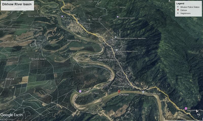
Satellite View: Google Earth Pro (Map data: Google, image @ 2026 Airbus)
True flood management requires a complete shift from political administrative boundaries to hydrologic boundaries, following the proven model used by Florida's water management districts. Rivers do not stop at district or state lines.
Assam must break its river systems into separate, autonomous Local River Watershed Authorities (e.g., a Dikhow Basin Board or a Buridehing Basin Board). This decentralized system relies on three pillars:
• Localized Public Boards: Each local river authority must be assisted by a public board of regional engineers, hydrologists, and community representatives. These boards lead local planning, target specific silted channels, and manage early warning systems directly.
• Land-Holding Fee Structure: Following Florida’s example, these localized districts can generate sustainable revenue by collecting fees based on land holdings and impervious surface areas. This funding flows directly back into regional river maintenance, avoiding slow central government bureaucracies.
• Granular Early Warnings & Mapping: Localized boards can quickly deliver precise flood hazard maps and telemetry-driven, village-level SMS warnings before dikes are overtopped. It can also enforce zoning laws requiring proponents to build houses in low lying areas above the base flood level (say 100-year flood).
To build long-term climate resilience, the newly formed watershed authorities must focus on four critical actions:
1. Scientific Levee Construction
Assam relies on over 5,000 kilometers of aging earthen dikes built decades ago as quick patches. Local authorities must upgrade these to engineered, climate-resilient "road-cum-embankments." These structures must be built on deep stilt foundations with integrated, automated drainage sluices to handle extreme water pressure without breaching.
2. Comprehensive Interstate Cooperation
Because major rivers flow into Assam from neighboring states, regional water agreements are vital. India must set up a cooperative system where the regulation schedules of upstream dams are managed with interstate input. Upstream operators must coordinate their water releases with downstream water levels in Assam to avoid causing artificial flash floods.
3. Systematic Wetland Protection
The Assam government’s Rs. 692-crore wetland restoration project is an important step forward. While engineering 15 retention tanks cannot solve the entire basin's problems, protecting natural wetlands (beels) and oxbow lakes is crucial. Preserving these water bodies keeps natural sponges healthy, allowing them to absorb millions of gallons of excess floodwater and lower peak river levels.
Assam cannot engineer its way out of this flooding crisis using temporary mud walls and seasonal relief camps. True flood resilience requires moving past political boundaries and managing water via its natural hydrologic borders. By shifting to a decentralized watershed authority model, enforcing strict mining bans, and coordinating regional dam operations, Assam can transform its strategy from managing frequent disasters to building long-term environmental safety.
 Navigations
  Quick Contact
 Subscribe Us
 Quick Mail